New destinations
New homes and destinations like this one have been built in South San Francisco in the past few years, and more will be coming in the future.
 SSF El Camino Real Mobility Plan
We developed design options based on your input from Fall 2025, and technical analysis. Learn more and share your input below!
This plan is South San Francisco's initiative to re-envision El Camino Real. Our goals are to design a street that is:
We developed three alternatives for El Camino Real, based on community input from Fall 2025, as well as technical analysis. Click through the tabs below to learn about each alternative compared to the existing El Camino Real.
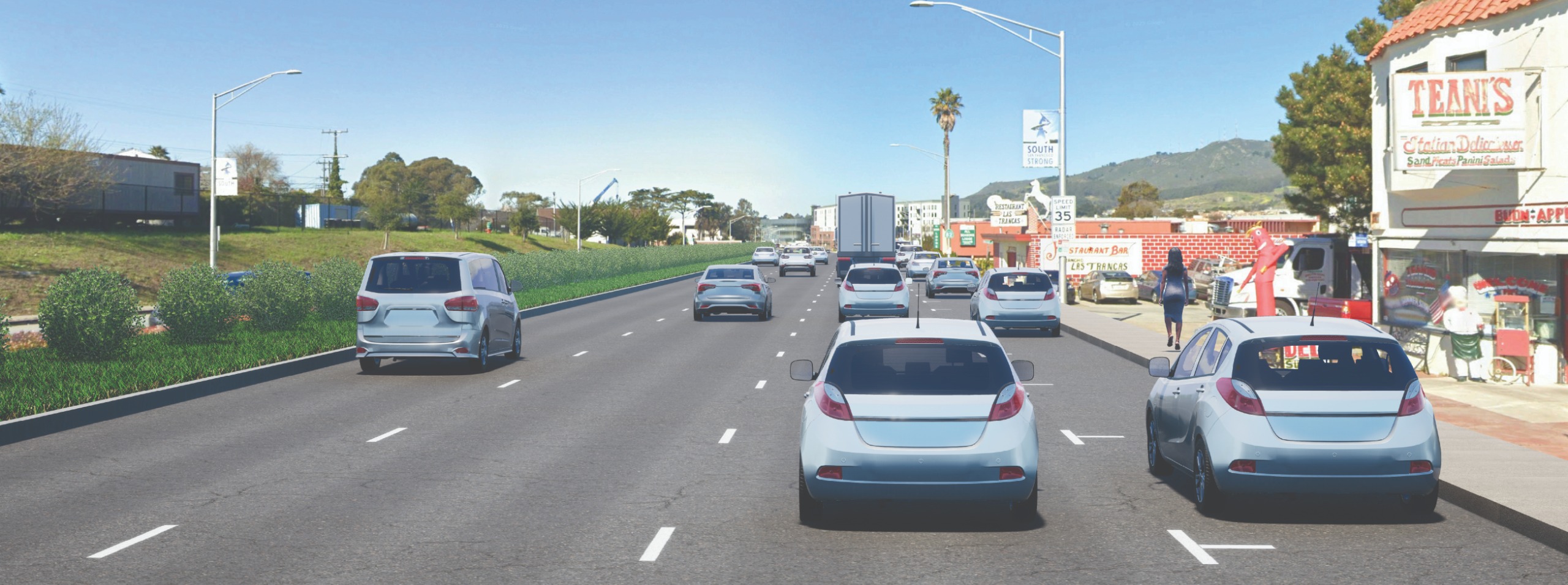
This image shows existing conditions. This is how El Camino Real is now, with three vehicle travel lanes, on-street parking, and sidewalks.
When evaluated by key project goals, the existing conditions scored:
🟥 Poor - Aligns with SSF General Plan
🟥 Poor - Prioritizes Safety
🟥 Poor - Enhances Pedestrian Connectivity & Walkability
🟥 Poor - Creates Seamless All Ages and Abilities Bikeway
🟥 Poor - Improves Transit Operations
🟥 Poor - Introduces Green Infrastructure
🟥 Poor - Preserved Critical Parking and Loading Zones
🟨 Good - Maintains Vehicle Travel Time
🟨 Good - Supports Emergency Response Operations
In addition to key project goals, we will also consider community input. Help us understand your thoughts by filling out the survey!
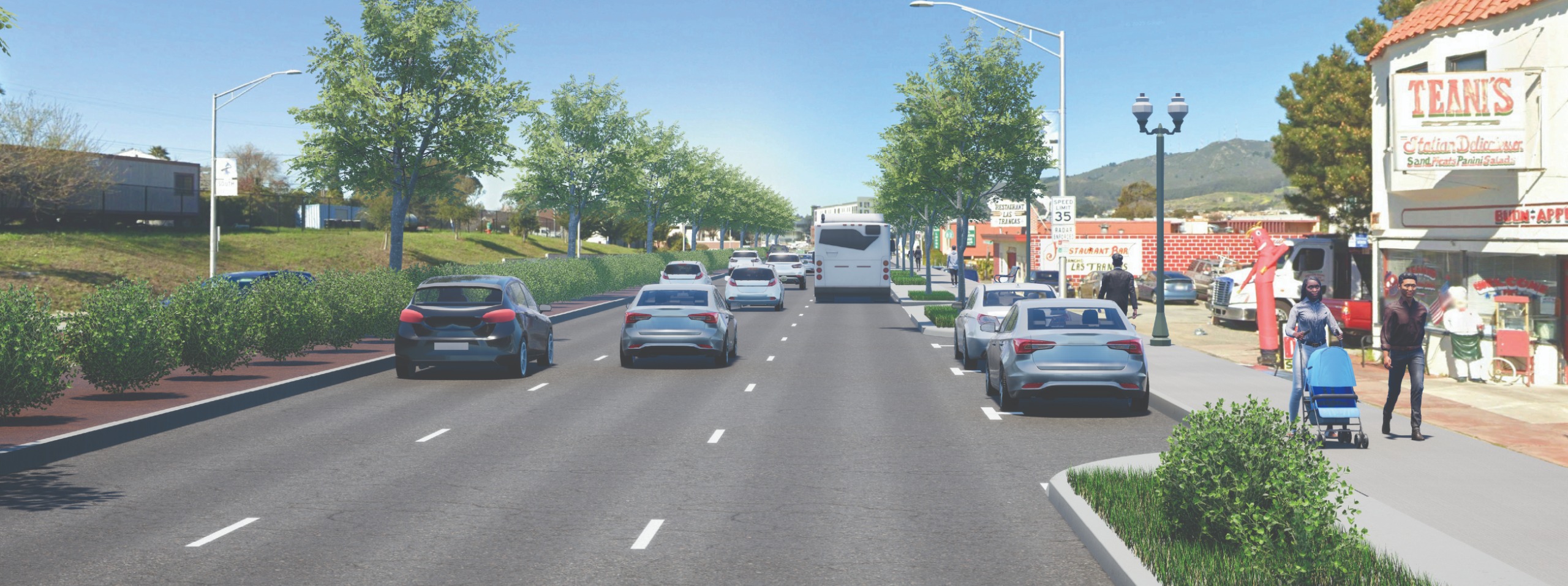
This image shows Alternative 1, which focuses on pedestrian improvements through:
Alternative 1 also maintains on-street parking to serve businesses and customers and provides a continuous shared use path (PDF, opens in new tab) on the west side, with connections to the Centennial Way Trail.
When evaluated by key project goals, Alternative 1 scored:
🟨 Good - Aligns with SSF General Plan
🟨 Good - Prioritizes Safety
🟨 Good - Enhances Pedestrian Connectivity & Walkability
🟩 Excellent - Creates Seamless All Ages and Abilities Bikeway
🟨 Good - Improves Transit Operations
🟩 Excellent - Introduces Green Infrastructure
🟨 Good - Preserves Critical Parking and Loading Zones
🟨 Good - Maintains Vehicle Travel Time
🟨 Good - Supports Emergency Response
In addition to key project goals, we will also consider community input. Help us understand your thoughts by filling out the survey!
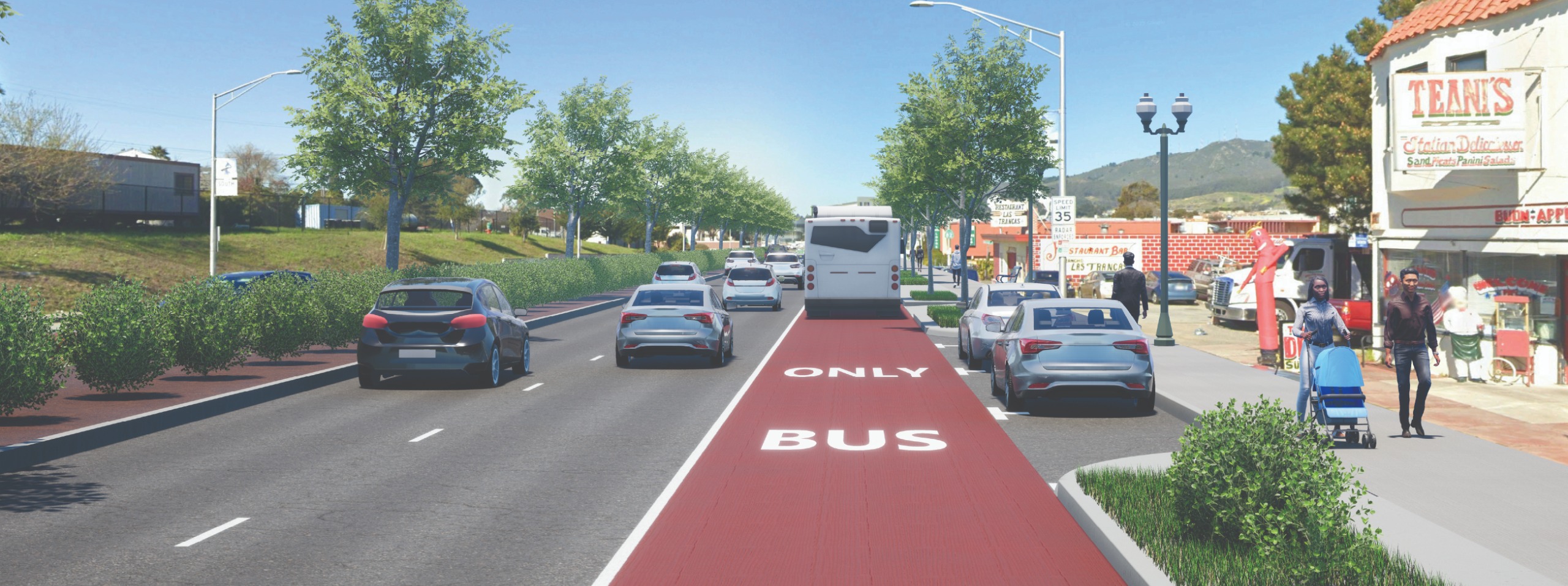
This image shows Alternative 2, which focuses on pedestrians and transit by:
Alternative 2 also maintains on-street parking to serve businesses and customers and includes a shared use path (PDF, opens in new tab) in some areas of El Camino Real to support connections to the Centennial Way Trail.
When evaluated by key project goals, Alternative 2 scored:
🟩 Excellent - Alignment with SSF General Plan
🟨 Good - Prioritizes Safety
🟨 Good - Enhances Pedestrian Connectivity & Walkability
🟨 Good - Creates Seamless All Ages and Abilities Bikeway
🟩 Excellent - Improves Transit Operations
🟩 Excellent - Introduces Green Infrastructure
🟨 Good - Preserved Critical Parking and Loading Zones
🟥 Poor - Maintains Vehicle Travel Time
🟩 Excellent - Supports Emergency Response Operations
In addition to key project goals, we will also consider community input. Help us understand your thoughts by filling out the survey!
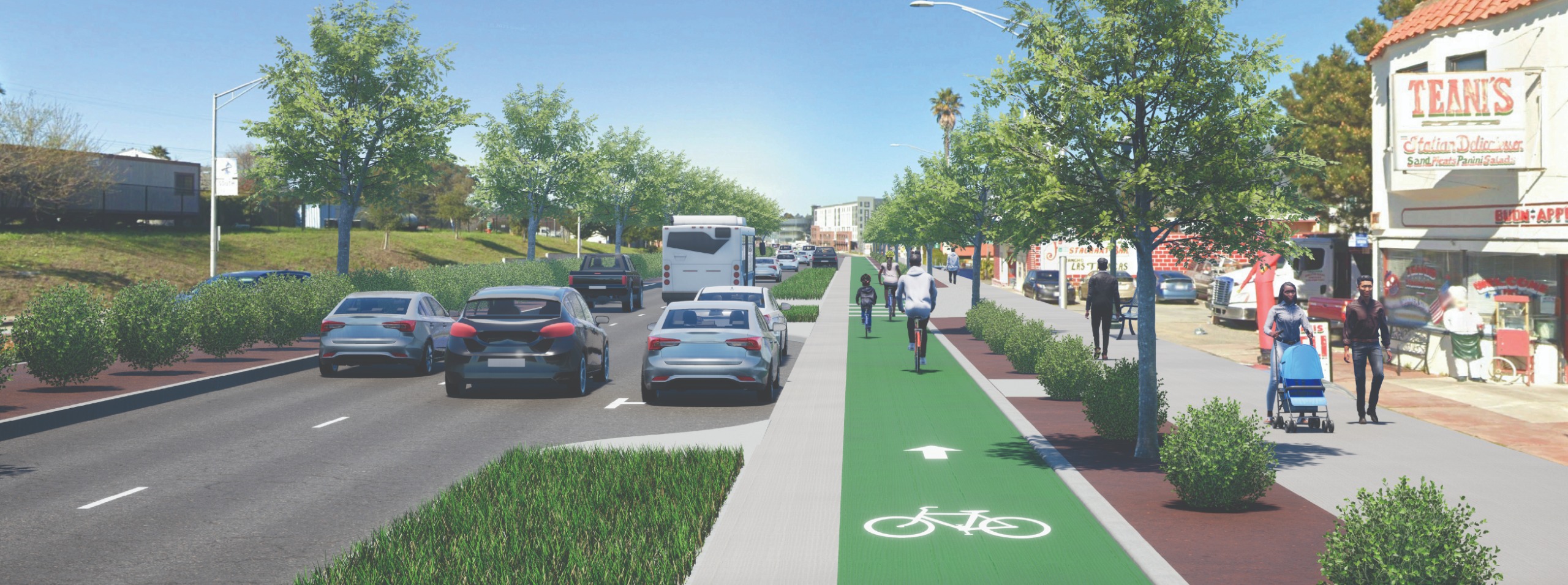
This image shows Alternative 3, which focuses on pedestrian and bicycle improvements through:
Alternative 3 would also maintain on-street parking to serve businesses and customers. Alternative 3 would require removing a vehicle travel lane, which would likely reduce bus speed and reliability.
When evaluated by key project goals, Alternative 3 scored:
🟨 Good - Alignment with SSF General Plan
🟩 Excellent - Prioritizes Safety
🟩 Excellent - Enhances Pedestrian Connectivity & Walkability
🟩 Excellent - Creates Seamless All Ages and Abilities Bikeway
🟥 Poor - Improves Transit Operations
🟩 Excellent - Introduces Green Infrastructure
🟨 Good - Preserved Critical Parking and Loading Zones
🟥 Poor - Maintains Vehicle Travel Time
🟥 Poor - Supports Emergency Response Operations
In addition to key project goals, we will also consider community input. Help us understand your thoughts by filling out the survey!
Here is another overview of how each of the three alternatives performed according to each key project goal. These are the same goals described above with the alternatives, but consolidated by goal. For more details about each goal, you can also review the full evaluation matrix (PDF, opens in new tab).
New homes and destinations like this one have been built in South San Francisco in the past few years, and more will be coming in the future.
Driving is and will continue to be a primary way to use El Camino Real. Many people also walk, bike, and take the bus.
While some places are safe and comfortable, others are not. For example, at this intersection, there is no crosswalk for people to cross the street to get to businesses or homes.
The Mobility Plan will identify concept designs showing improvements to El Camino Real that help us meet our goals of a safer street and a more pleasant experience for everyone.
We will identify the concept designs through technical analysis and input from community members. Your input through attending events and sharing thoughts on the survey and map on this website are important for us to determine which recommendations to include in the Mobility Plan.
Currently, El Camino Real is the most dangerous street in the Bay Area region. El Camino Real has unusually high rate of crashes that cause fatalities or serious injuries, especially for people walking or biking.
People walking and biking are more likely to be severely injured or killed in a collision:
Speeding is the leading cause of collisions that result in injuries on El Camino Real.
Currently, El Camino Real in South San Francisco has challenges for all types of users! For example:
This South San Francisco project will feed into SamTrans' Grand Boulevard Initiative (GBI). GBI is a collaboration in San Mateo County between 14 cities and towns, three countywide agencies, and Caltrans. The project aims to make El Camino Real a safer and more connected place to walk, bike, drive, and take transit by installing roadway improvements along the corridor.
South San Francisco is collaborating with SamTrans to include this plan as part of the GBI Action Plan, a planning document that evaluates corridor-wide needs and establishes a cohesive vision for El Camino Real in the county. The GBI Action Plan was finalized in January 2026. GBI is now advancing to the next stage of the Caltrans project development process, the Project Initiation Document, which began in April 2026. For more updates, please go to the GBI project page.


